About
The Landscape Knowledge Visualisation Lab offers a variety of simple and easy-to-use technological communication solutions. The technology brings spatial data and local knowledge together to create tactile sharing spaces facilitating two-way learning about the environment, science, and culture in diverse, cross-cultural, cross-linguistic contexts worldwide.
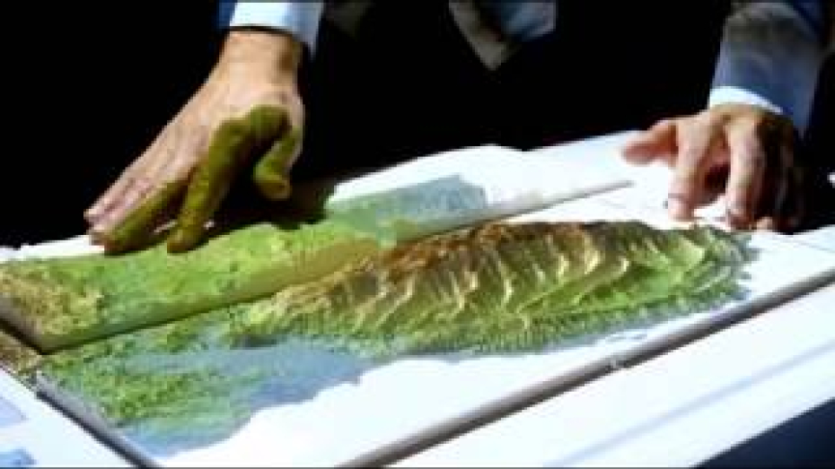
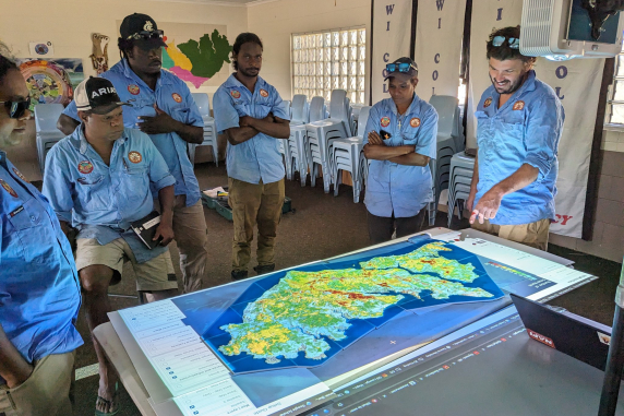
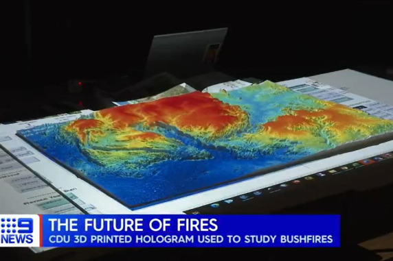
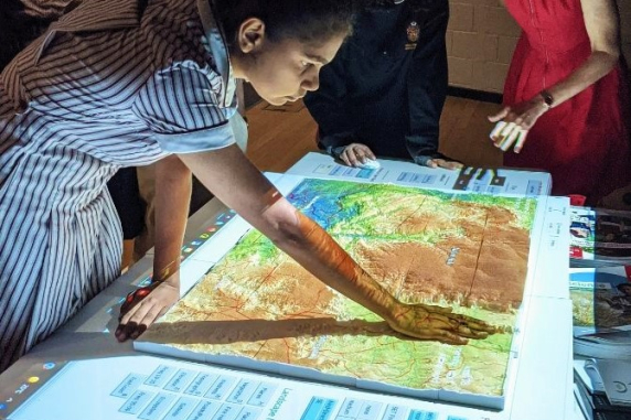
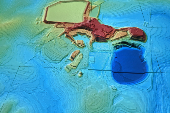
Projection Augmented Landscape Models (PALMS)
PALMS are simulations of landscape processes projected onto 3D-printed terrains, creating a surface to display complex information. Sand or high-resolution 3D printed models are used as terrain surfaces over which projected spatial data, landscape process animations and simulations are displayed. Using projection in combination with 3D landscapes adds interactivity and dynamism to spatial information. Simple, Robust and Scalable technology.
Find out more at landscapemodels.net.
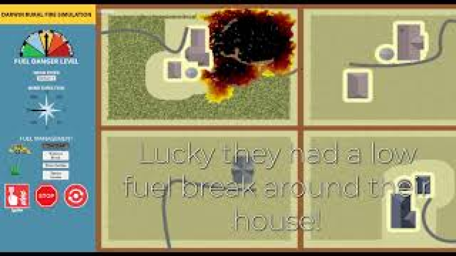
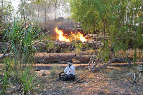
Fire Simulation Games
PALMS are simulations of landscape processes projected onto 3D-printed terrains, creating a surface to display complex information. Sand or high-resolution 3D printed models are used as terrain surfaces over which projected spatial data, landscape process animations and simulations are displayed. Using projection in combination with 3D landscapes adds interactivity and dynamism to spatial information. Simple, Robust and Scalable technology.
Find out more at
Go to the online Fire Simulation Game.
Applications
Indigenous and Local Knowledge Exchange
3D landscapes provide an ideal way to view climate change impact models related to flood and coastal inundation. Making the vertical dimension of topography and the built environment explicit helps to produce a better understanding of these risks. Often, sophisticated modelling of the potential climate change impacts is poorly communicated to local governments and communities that are the most affected and on the frontline of impact mitigation. Recently completed work (pictured right) for The Pacific Community (TPC) displays tactile 3D visualisations of climate change-induced inundation impacts.
Fire Management
3D landscapes augmented with fire simulation models support diverse engagement and training applications. Descriptive fire simulations tailored for the savanna landscapes of Northern Australia are used
to illustrate both landscape-scale fire management and the interaction between weeds and fire at a finer scale on rural blocks. The fire models have also supported Indigenous elders in sharing their experiences of fire on Country with younger generations and non-Indigenous colleagues, empowering Indigenous knowledge in a field dominated by hard science data.
Climate Change Adaption
3D landscapes provide an ideal way to view climate change impact models related to flood and coastal inundation. Making the vertical dimension of topography and the built environment explicit helps to produce a better understanding of these risks. Often, sophisticated modelling of the potential climate change impacts is poorly communicated to local governments and communities that are the most affected and on the frontline of impact mitigation. Recently completed work (pictured right) for The Pacific Community (TPC) displays tactile 3D visualisations of climate change-induced inundation impacts.
STEM Education
Creating a 3D terrain surface to display landscape data and simulations helps understand environmental data and the topographic effects on landscape processes. This innovative teaching technology received national
recognition and was awarded the 2018 AFR National Education Technology Award. This approach has been used by CDU since 2016 in a variety of teaching and cross-cultural and inter-generational knowledge exchange contexts for tertiary-level teaching and in Northern Australian remote Indigenous community contexts.
Mine closure and site visualisation
The projection-augmented models provide a powerful way to visualize current and post-mine landscapes. They support the clear communication of a complex array of mine site data, including cultural heritage and modelled biophysical processes. Making the third dimension explicit and tactile assists in building an understanding of landforms and biophysical processes in mine landscapes. The technique has been applied to support engagement with external stakeholders and internal planning discussions.
Team
Dr Rohan Fisher
Lead Researcher
View research profile
Miguel Tovar Valencia
Research Associate
View research profile
Media Engagement
In the media
2023
Northern Institute acknowledges the Traditional Owners of Country on which we live and work and recognises their continuing connection to communities, land and waters. We pay our respect to Aboriginal and Torres Strait Islander cultures and elders past and present. Our Research Support Services is located on Larrakia Land at CDU Casuarina Campus. Find out more about Larrakia Nation (Saltwater People)
⚠️ Aboriginal and Torres Strait Islander peoples should be aware that this website, linked publications and content may contain images, voices and names of people who have passed.